Garmin is a household name, especially if you’re an athlete. The company has a detailed lineup of wearables for any sporting activity, regardless of your fitness level. What most of us don’t know is that much of the usability of their smartwatches evolved from specialised products first seen in aircraft for navigation purposes. Since the US opened the GPS market for consumers and the wider public, tech companies were soon to grab the opportunity to widen the scope of GPS products beyond military and security applications. Garmin went on to produce its ProNav100 Navigator for civilian aircraft and their Street pilot made navigating streets easier. Both products were released in the 1990s, but the GPS landscape has changed substantially since then.
Garmin’s Range of Avionics
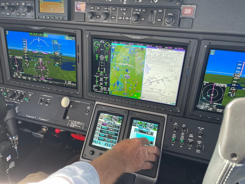
Avionics subtly blends aviation and electronics. This is the gear that’s used to monitor engine controls and flight systems, provide navigation and a way to communicate with air traffic control and other aircraft, record various flight data, warn of potential threats, get pilots the latest weather updates, and so much more. Garmin prides itself on innovation and delivering avionic products and systems with industry-leading capabilities to help pilots of both small recreational aircraft or larger commercial planes gain optimal situational awareness during every flight and in all conditions.
Source: facebook.com
If you’re looking to update older systems on your aircraft, here are a few popular Garmin avionics systems and products to choose from:
Portable GPS Systems
Aera®660 and 760 Navigators
These are well-regarded navigators primed with a wealth of features. The smaller and less expensive of the two, the Aera® 660 is based around a 5-inch capacitive touchscreen and comes preloaded with fully-detailed navigation maps, configured with the terrain and obstacle alerts, and can is compatible with a host of flight-planning apps (such as GarminPilot) as well as the capability of interfacing with the company’s GDL 39 3D portable ADS-B data link for a unique 3D view around the aircraft, including nearby land and water features, obstacles, runways and airport signposts. What’s more there’s reliable GPS for consistent performance Buyers get the navigator, a battery, AC adapter as well as mounts and cabling included.
Move up to the Aera® 760 for even more functionality and usability. This builds on all the goodies of its smaller sibling. It has a larger, less reflective 7-inch display, the ability to load full aircraft approaches, built-in AHRS, built-in GPS/GLONASS receivers, Bluetooth and WIFI connectivity, and fully featured flight charts and maps. It’s highly capable as a standalone GPS unit, but there are more features to be had when wirelessly connecting with Garmin’s wide array of avionics equipment, such as a dedicated ADS-B receiver, or Garmin panel-mount avionics to view things like real-time weather and traffic alerts. Other differences include an integrated PDF viewer to allow importing PDF files from a MicroSD card. The navigator sits nicely on kneeboards and is sized right, and the more detailed info, higher legibility, and resolution make this a better buy for most.
GDL® 52 Portable SiriusXM®/ADS-B Receiver
If you need satellite radio and subscription-free weather and air traffic updates, as well as GPS positioning, aircraft attitude, and the flexibility of the GarminPilot app and connectivity with the Aera series navigators, then the GDL52 is for you. This is a fully featured ADS-B receiver with included ADS-B In (for weather and traffic position) and ADS-B Out (for ground speed, GPS location, and altitude) for ATCs and nearby aircraft. This piece of Garmin avionics lets pilots be visible in the skies and informs of potential threats and changes in weather that will affect their flight. It also simplifies listening to high-quality satellite radio either through wired or wireless headsets or through integrated audio planes in the aircraft. Units are powered by a rechargeable battery good for 5 hours of flight time and adapter cable lets you plug the device into your airplane’s 12V outlet for lasting performance.
Smartwatches and Satellite Communicators
Garmin’s known for fitness wearables, but its line of aviators is in a league of its own. The D2 Mach1 and the D2 Air X10 pack things like navigation to location or waypoint, moving maps, weather reports, airport info, flight logging as well as basic pilot watch smarts like alerts, timers, and time zones. These beam through a crystal-clear 1.3” AMOLED display with touchscreen functionality and an impeccable design based around a titanium bezel and sapphire lens for durability, while leather or titanium straps offer unrivalled comfort. The AIR X10 is a pared-down version of Mach1, but still has all the flight and navigation basics, and like its bigger brother sports pulse oxygen sensors to calculate how your body is coping in thinner air.

Source: instagram.com
Last on the list of recommended Garmin aircraft products are the InReach series of satellite communicators. These are effective both on the ground and in the air and use satellite-enabled communications systems for two-way messaging, emergency alerts, location tracking as well as weather updates in a tough, durable, and water-resistant design. Choose the InReach Explorer+ for all the bells and whistles or save some cash and weight and go with the InReach Mini 2. Both devices have free cloud storage and apps (Garmin Explore) and for aviation uses, sync with systems for pre-flight planning.